Other Case Studies
The SMART partnership supports improved law enforcement and biological monitoring in protected areas around the world. They came to Refractions to build a software tool to help meet their needs.
Hectares BC – Biodiversity BC on behalf of a broad partnership
Biodiversity BC and its government and non-government partners were looking for regional-level environmental statistics. Refractions proposed a new approach to generating GIS summaries, using the power of a relational database and web tools to provide GIS analysis to users who previously had no access to it.
Automated Route Planning for Meter Reading – City of Vancouver
The City of Vancouver collects water readings from thousands of residences and businesses, but has never optimized the pedestrian routes the readers take. Refractions developed algorithms to create the most efficient routes of the correct length for readers.
Digital Road Atlas – BC Integrated Land Management Bureau
Refractions provides full-service support for the British Columbia Digital Roads Atlas – systems design, maintenance, data conflation, client service, and rapid response.
Caribou Habitat Assessment and Supply Estimator – Wildlife Infometrics Inc.
Refractions converted a legacy habitat modelling system based on ArcView 3.X to ArcGIS 9.2, and automated the workflow to provide faster turnaround time for model runs.
Line Cleaner – BC Ministry of Forests
The British Columbia Ministry of Forests needed a tool to conflate multiple roads databases into a single working layer. Refractions delivered the algorithms and a user interface based on the uDig platform.
Interest Reports – BC Ministry of Agriculture & Lands
Refractions developed an ArcMap extension to automate the calculation of standard reports joining a massive shape-file archive with a large Oracle database.
Mobile GIS – UN Food & Agriculture Organization
UN FAO needed a data collection tool that could run disconnected and didn't have a per-seat licensing cost. Refractions delivered a simple tool using the uDig desktop platform.
Open Web Services, Phase 3 – Open Geospatial Consortium
The Open Geospatial Consortium runs regular “testbed” projects to field-test new concepts in geospatial interoperability. Refractions was a part of the OWS-3 initiative, and built a uDig-based “GeoDSS” client to provide access to several other OGC standard services, including a prototype GeoVideo service.
Natural Language Spatial Search Engine for Rental Places-Rento
Rento is a free web service that makes it easy to find a place to rent in Greece. Powered by PostgreSQL and PostGIS, it provides ad listings with photographs displayed on a map. Searching is accomplished through map navigation and natural language processing, with the search engine being capable of answering complex (spatial) questions such as "flat near the University of Athens" or "loft up to 800 euros near a metro station" (in greek).
Line Cleaner – British Columbia Ministry of Forests
The Client
Ministry of Forests
Government of British Columbia
2006
The Problem
The BC Ministry of Forests (MOF) uses several road data-sets when building triangulated irregular networks (TIN). TINs help MOF to plan and/or permit forest road building, as MOF prefers that timber cut-blocks be accessed from existing roads rather than from forest roads newly built for the purpose.
Because of close but not exact feature replication among and within the road data-sets, TINs tend to be complicated by nests where features do not meet as they should. These areas are time-consuming to fix or remove.
Refractions has the necessary expertise to combine data sets and remove all redundancies, a process known as “conflation-based data integrations.” However, since MOF's data-sets contain several million features, conflation on this scale would exceed MOF's allotted time-frame for this project. (Full-scale conflation demands dividing data-sets into manageably sized sub-sets, and a significant amount of validation and un-grouping post-conflation.)
Refractions considered brute-force manual processing, but discounted it because of the sheer number of features not only to process, but also on which to maintain proper topology and enforce consistent visitation and treatment. Eventually, the time and effort required for manual processing would approach those required for full-scale conflation.
Refractions' Solution
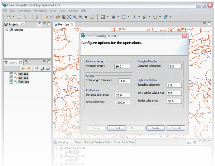
With the constraints of conflation, and with their original goal and intended purpose in mind, MOF allowed Refractions to work under the proviso of being quite severe with the data. The solution is LINE-CLEANER, a “light conflation” application that works in two phases:
- Cleanse – makes candidate networks as similar as possible, and
- Clean – considers cleansed features automatically for spatial similarity and removes any redundancies.
LINE-CLEANER cleanses networks by simplifying complex, cyclical, very short and zero-length geometries, and removing pseudo-nodes and insignificant vertexes. Most significantly, in the cleansing phase, it is able to ensure that feature matches can be considered automatically.
The rigorous cleansing phase allows data cleaning to avoid both complex networking and pathing. Feature-by-feature, equivalents are considered, and either match others or do not. Since connectivity between data sets has been rationalized to common points, simple precedence tests can be conducted to determine which of the N close features to keep, and throw away all others. Connectivity to other features is also not an issue, having co-located all nodes.
LINE-CLEANER was developed as a plug-in to Refractions' uDig spatial applications framework. While developed specifically for MOF, LINE-CLEANER will work on virtually any linear data-set(s). Both uDig and LINE-CLEANER are distributed free of charge under the Lesser General Public License.
The Result
LINE-CLEANER has met MOF's early acceptance criteria and is currently being reviewed and tested before it is launched into production operations. Refractions expects the system to be fully deployed in the summer of 2006.